The Superstition Mountain Lost Dutchman Museum was closed the last time we were on the Trail and wanted to check it out this time. The museum has lots going on and in January they will have hiking trips in the Sonoran Desert which we will be attending. Years ago it was know as the Apacheland Movie Ranch as several movies where filmed here. There are reproductions of 19th Century businesses including Wells Fargo office, stage coach stop, Audie Murphy barn with stage coaches and lots of filming history.
Trail leading to the 20 Mill Stamp with the Superstition Mountains in the background.
This 20 Mill stamp ore crusher was state of the art technology for recovering gold in the 1800's.
The Elvis Memorial Chapel is also a museum showing all the movies that have been filmed at Apacheland Movie Ranch. Probably the most famous was "Charro". Today it can be reserved for weddings.
----------------------
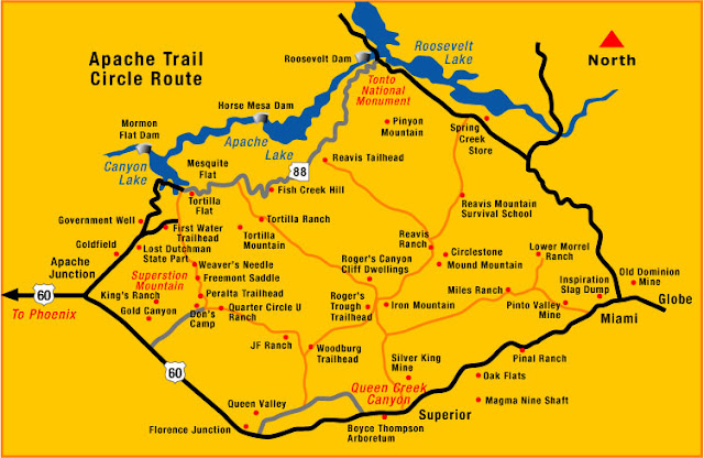
This is a map of the route that we took.
Back on the Trail it begins to bend sharply as the land becomes steeper, and passes along the shores of Canyon Lake, one of four formed by damming the Salt River, the course of which runs right through Phoenix but is dry for most of the year.
After Canyon Lake you will come to Tortilla Flat.
Tortilla Flat has a population of 6! There is a Post Office, the Superstition Saloon and several other little shops. We did eat in the Saloon and the food was OK but probably wouldn't eat there again. A better idea is to pack a lunch and enjoy it outside at one of the several stops along the trail looking at all of the beautiful scenery. But you do have to check out the Saloon as it is a real cool place. The walls are wallpapered in dollar bills,
the bar stools are actual saddles,
and they have dancing girls in the bathroom!
A fun place to check out along the trail.
Just a short distance past Tortilla Flat the pavement ends and you than travel 22 miles a on gravel road leading to Roosevelt Dam.
There are no guard rails so you better pay attention!
The gravel road is a wash board in most spots. You don't need a 4 wheel drive to travel on it, just drive slow and enjoy. This section is the most scenic with views that will take your breath away.
From this point, you'll drive down 1,500 feet in elevation in a very short distance.
Leaving Fish Creek Hill

Simply Awesome. The mountains on my right are so tall.
This photo is taken out of the sunroof. Some fall color.
Leaving the bottom of Fish Creek Hill headed to Apache Lake.
Leaving Apache Lake
The road leads right on the edge of the lake, it is simply beautiful.
Leaving 3 Mile Wash you are about 2 miles from the dam.
I am fascinated by the angles of the layers of rock in the mountains.
Roosevelt Lake was created in 1911 with the completion of the Roosevelt Dam on the Salt River. At the time, Roosevelt Dam was the world's tallest masonry dam at about 280 feet high and Roosevelt Lake was the largest man made lake in the world. In 1996, modification of the dam increased its height to 357 feet and expanded the lake's water storage capacity by 20%. The lake had a multi-purpose of flood control, generation of electricity and harnessing the water for irrigation. The dam, lake and its water distribution system turned the Arizona desert into fertile agricultural land.
So there you have the Apache Trail. It is a must see and do when you are in the area. We got a late start this morning and by the time we got to the dam it was 4:30. Our route home was on 188 to Globe then 60 back to Mesa which would have been a nice ride during the day as elevations are above 4,000 ft. You will pass by copper mines in Miami and other points of interest worth seeing but we will have to save that for another day.
I hope you enjoyed the trip as much as we did!
Life is good.


Hola, Gypsy,
ReplyDeleteWhat a trip! Such majestic geography, from flat sand to jagged mountains. I hope you get back to kayak...
Glad you're feeling better!
love and smooth miles, k