
It seems no matter what direction you look, you will see mountains. Looking to the East it will be Superstition Mountains which are beautiful. So come along on the ride with us and enjoy the sites...
Heading East on Main St you pick up 88 know as Apache Trail which is a 2 lane road that twists and turns, just perfect on a motorcycle. First you will come to Goldfield...

Situated atop a small hill between the Superstition Mountains and the Goldfield Mounts, the settlement of Goldfield got its start in 1892 when low grade gold ore was found in the area. Low-grade or not, a town soon sprang up and on October 7, 1893 it received its first official post office. New miners came to the area and in no time, the town boasted three saloons, a boarding house, a general store, brewery, blacksmith shop, butcher shop, and a school. For five years the town boomed until some 4,000 souls were residing in the burgeoning city.
But like other gold camps, Goldfield’s bustling days were quickly dashed when the vein of gold ore started to play out and the grade of the ore dropped even more. Just five years after it began, the town found itself quickly dying. The miners moved on, the post office was discontinued on November 2, 1898, and Goldfield became a ghost town. In 1921 the town had a rebirth but again died in 1926.
Robert F. "Bob” Schoose moved to Mesa in 1970 and soon began to dream of owning his own ghost town. He had heard of the old site of Goldfield, but upon inspection, how found little left other than a few foundations and rambling shacks. He and his wife, Lou Ann, then located another five-acre site that was once the location of the Goldfield Mill and decided with to rebuild the old town. Purchasing the old mill site in 1984, they first reconstructed a mining tunnel, which included a snack bar and opened for business in 1988. Next came a photo shop, the Blue Nugget, a General Store, the Mammoth Saloon and the Goldfield Museum.


The ceiling in the Saloon


Leaving Goldfield

Superstition Mountains
and a mile up the road on your right is The Lost Dutchman State Park.

We had packed a lunch and decided to enjoy it at the park while looking at Superstition Mtn.

Arizona's Superstition Mountain has long been the source of stories and tales about lost gold and legends of the Dutchman's Lost Gold Mine.
What is the origin of the name Superstition Mountain? The best answer to this question centers around the early farmers of the Salt River Valley who grew and cut hay for the Army at Fort McDowell during the late 1860's. These farmers constantly heard stories from the Pima Indians how they feared this mountain. The farmers thought the Pimas were superstitious about the mountain hence the name Superstition Mountain.The Lost Dutchman Mine is reportedly a very rich gold mine located in Superstition Mountain. The mine is named after German immigrant Jacob Waltz who is said to have found the mine. He would disappear for months and then show up in town buying drinks for everyone and paying in gold nuggets. Waltz died carrying the exact location of the mine to his grave. Several men and women have risked everything in search of the mine and ended up with nothing. Does it really exist? Depends on who you talk to.
The park has camping sites with electric and is well maintained. They also have hiking trips that sound interesting.
Back on the bike and headed to Canyon Lake.

The Apache Trail, aka Arizona 88 cuts through the desert, but before long, it begins to turn sharply, then turn again, hugging cliffs, and rising and falling with the hills and valleys of the landscape.
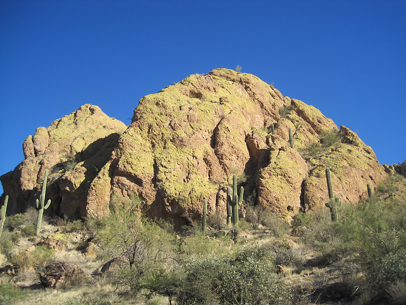
This picture doesn't really do justice as the mountain looks yellow because of a yellow moss that grows on it.


You come around a curve and see Canyon Lake, one of the salt river lakes accessed by the Apache Trail.


We turned around here and headed back home as it was getting late. But just a bit up the road will be Tortilla Flat but after that it is 20 miles of dirt road not suitable for the bike. We will come back with the truck for the 20 mile stretch. Round trip is 175 miles so when we head out on the bike again we will take 60 to 88 which will take us to the Roosevelt Dam.
Back at Gypsy Camp Mark has turned into a real Arizonian.


As for work things are good. Our days are Friday, Saturday and Sunday delivering the party wagon, setting up for events and decorating for the holidays.
Glad to see you all are doing good. Take care and have a Merry Christmas if we don't talk to you before. John Greene
ReplyDelete