Once we got to the mainland and loaded up we headed south to
Anchorage to Jimmie and John’s house, actually it is now their sons house as he
bought it from them. Jimmie is an OR
nurse and she stays there when she is in town working.
We followed her making the 3-hour ride into town stopping at Mantanuska
Glacier.
A glacier moves faster in the center where the ice is the
thickest and slower along the edges.
Back at the house we got settled in then went for a beer at
the Fire Tap. The Alaskan brewed beer
is great; the one we really liked is called Alaskan White, wonder if they sell
it in the lower 48. There was this
mural we spotted about whales and with a closer look it was done by the artist
WyLand. We have a WyLand mural in
downtown Wilmington NC.
The next day we did some shopping and that evening we met
their other son Shawn and his wife Randee along with their daughter Clara for dinner. We had a wonderful time, thanks again
Jimmie.
The following day Jimmie went to work and we left headed
south to Seward. We passed a car that
had caught on fire but thankfully no one was hurt.
Traveling south on Hwy 1 also known as the Seward Highway,
which provides access to the Kenai Peninsula.
It winds along the north shore of Turnagain Arm, crossing the isthmus
that separates the Kenai Peninsula from the rest of south central Alaska. This is a beautiful drive with views of the
glaciated Kenai Mountains and lush green mountainsides.
172 miles south of Anchorage is Seward-known as the “Gateway
to Kenai Fjords National Park”-a picturesque community nestled between high
mountain ranges on a small rise stretching from Resurrection Bay to the foot of
Mount Marathon. Historically, it was an
important transportation hub for Alaska’s mining, exploration, fishing and
trapping industries. Resurrection Bay,
a year-round ice-free harbor, made Seward an important cargo and fishing port
as well as a strategic military post during WWII.
The campground was packed on Resurrection Bay with spots along the shore all taken, we didn't plan on staying but it had wonderful views.
12 miles north of Seward is the turn off for Exit Glacier in
the Kenai Fjords National Park. Before
you enter the park you can see the glacier.
Once in the park we sprayed down with bug spray and started
the hike to the glacier. The glacier is
2.4 miles long and descends some 3,500 feet from the Harding Icefield, very
impressive.
I like the blue color the glacier has.
The glacier flows downhill about a foot each day. At one time not so long ago the glacier
covered the area where this picture was taken from.
We left the glacier and headed to Soldotna. The drive takes you along the Kenai River,
which is beautiful and is noted for some of the best fishing. Once in Soldotna we stopped at Fred Meyer,
which is a great store that sells everything from milk to canoes. They are like a Walmart that lets you camp
in their parking lot. Well let me tell
you there had to be at least 50 campers there so we spent the night there, they
even had porta potties!
The next day we headed to Homer. Once again you are on Hwy 1 with the Cook Inlet on your
right. We were lucky to have a
wonderful clear day making it possible to view Mt. Iliamna and Mt. Redoubt both
of which are in the Ring of Fire that encircles the Pacific ocean. They are Volcano Mountains; Mt. Redoubt last
erupted in 2009.
Deep Creek is known for freshwater fishing and several
fishing charter services launch their boats from here. It was a very busy place and fun to watch
the boats being launched. King salmon
is what the fisherman hopes to bring back.
The water is shallow so the tractors push the boats out pretty far
before they can take off.
Before reaching Homer there is a rest stop with views of
Cook Inlet.
Homer has a population of 5,400 people and jutting out for 4.3
miles from the Homer shore is the Homer Spit.
The Spit is the site of a major dock facility for boat loading,
unloading, servicing and refrigerating.
The deep-water dock can accommodate large cruise and cargo ships. As a matter of fact the commercial crabber
called the “Time Bandit” from the show “Deadliest Catch” calls Homer its
home port but unfortunately they weren’t there.
There are lots of shops and eating establishments along the spit as
well.
On the way back to Anchorage we stopped at Alyeska in
Gridwood, which is 40 miles south of Anchorage. It is a premier resort that has a scenic aerial tram that carries
you 2,300 ft up a mountain for spectacular views of the surrounding wilderness
including the Cook Inlet, hanging glaciers and endless mountain peaks.
We finally saw some wildlife, once we got down
from the mountain there was a bear wandering around through the parking area.
Back in Anchorage at Jimmies we chilled for a few days doing
laundry and getting ready for the next leg of the trip. We wandered around the downtown area taking
in the sights and some of the shops.
One shop we stopped in was David Green Furs. I can’t say that I have ever really touch real fur let alone put
one on. The sales lady was so nice
answering our questions and she even let me try on a coat. Again what was I thinking not getting a
picture. OMG it was so soft and looked
so good on me but at a cost of $5,000 I passed on the purchase. Then she showed us the vault where the extra
coats were stored in a climate-controlled environment, it was amazing! I am a thrift store kind of gal but it sure
was fun to pretend.
Later that evening
we went to Earthquake Park with hopes of seeing some moose and we hit pay
dirt. Driving in we spotted a Cow and
two calves; I was a happy girl taking lots of pictures. Continuing on to the park we got out of the
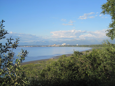
truck and enjoyed the view of the Cook Inlet and downtown Anchorage.
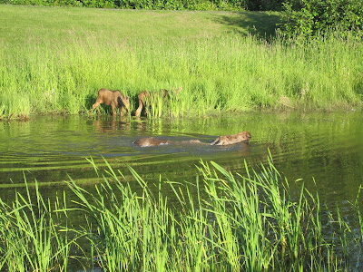
Heading back to the truck we spotted the same cow and calves
walking to a watering hole right in front of the truck!!!
Momma was enjoying a swim but the kiddos weren’t to sure so
they just grazed along the edge. The
airport is just behind where they were and when a plane took off it didn’t
bother them a bit, it was just too cool to see them this close.
By this time it was around 9:30pm and the sun was low in the
sky, you would have thought it was only 6 pm.
Once back at the house later that evening around 11:30pm I
took this picture off the back deck.
See what I mean the sun just never really goes down and that takes some
getting use to.
The next morning we loaded up heading north on Hwy 3 with
our destination being Denali National Park.
The drive took us about 3 and half hours to get there but even before we
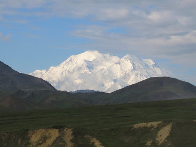
reached the park Mount McKinley was visible.
Broad Pass is a beautiful area. A mountain valley, bare in some places, dotted with scrub spruce
in others, and surrounded by mountain peaks.
We arrived at the park on a Saturday and there were no
campsites available so we went down the road 6 miles to another campground.
Bright and early the next day we showed up at the park for a
bus ride at 6:30 am. The purchase of
our tickets was made the night before; it is better to go early as your chances
of seeing wildlife is greater. You can
only drive into the park 18 miles so you have to take a bus to really see the
park.
Mount McKinley or Denali is the highest mountain peak in
North America, with a summit elevation of 20,320 feet above sea level. At some 18,000 feet, the base to peak rise
is considered the largest of any mountain situated entirely above sea
level. Not to long into the ride we
spotted a caribou and a bear.
The bus stops at several points for pictures,
breaks and visitor centers.
That moose antler was incredibly heavy and large. On average a set of antlers weigh around 40 lbs, talk about a headache!
The bus driver informed us that we were in the 30% club as
only 30% of the folks that come to the park actually get to see Mount McKinley.
Before we got to the visitor center at the Tundra there was
this fox that was just trotting along the road.
Once we got to the tundra the clouds had started
to move in, covering the mountain.
In the visitors center they had this posted.
On the way back we came across this caribou that was just
walking up the road.
We enjoyed our time in the park and it is a must see when in
Alaska but you need to make reservations for campgrounds and bus rides. Seeing wildlife was a plus as we had talked to some folks who hadn't seen anything but a squirrel. Oh don’t forget the bug spray!!!
Once we left the park we headed on to Fairbanks and had some
dinner. I will have to say we didn't
see much there to excite us to stay for the night so we started the trip
south. We passed by the famous pipeline.
. The next pictures show how the size of the pipeline has increased over the years.
Next it was the end of the Alaskan Highway 101
miles from Fairbanks.
There was also this display depicting the size of misquotes
in Alaska and it is the truth, look out as they are coming for you!
Remember it doesn't get really dark at night so we continued
to drive on through the evening switching drivers. Early in the morning we stopped for a few hours of sleep at a
rest stop. When we got up the next
morning we were greeted by swans swimming on a small lake, it was
beautiful. Sorry my picture doesn't do
them justice.
I have so say by this time we were ready to get back to they
lower 48 and our caravan, so we pressed on.
From Tok we took a different route leading us to Whitehorse and then
onto Watson Lake, from there we jump on the Cassiar Highway leading to Prince
George. The scenery was just a
beautiful with all the mountain views one could take in. All along the roadsides you would see these beautiful purple flowers that are called fire weed. We passed by a forest that had recently been burned and now I know why they were given that name. The whole forest floor was covered in them!
We decided to stop for the night at Boya Lake Provincial Park. It was a really nice campground on a lovely lake.
The water was the prettiest shade of blue/green.
When we arrived there was a family swimming and they were commenting on how nice the water was so Mark decided to check it out. I think he was in the water for a total of 15 seconds, OMG it was cold. I wouldn't even put in my little toe! We had dinner by the campfire enjoying the view of the lake.
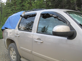
Since we really didn't have a good rest the last night Mark made sure we would tonight. He put a tarp over the back half of the truck and then covered the windows with black trash bags blocking out the light, we slept til 9 am the next morning!
Moving on the next day we passed through a remote area that was having power lines installed. They were huge metal poles on top of steep mountains making one wonder how they got them installed. Well further down the road we stopped for gas and found out. Next to the gas station there was the headquarters for the workers. They were taken to their work stations via helicopters and there was this huge helicopter thing that would pick up the poles and set them. My hat is off to those workers.
The last bit of wildlife that we saw was another bear.
Once again we drove on through the night as we really wanted to get home. Crossed the border the next day around 11 am. It was a good trip traveling 5,000 miles with only 3 rock chips in the windshield, a couple on the fenders, a broken Chevy emblem on the front, but no flat tires and the only thing we hit was a seagull and a bird. Once again we are so happy we didn't bring the caravan!!!
Thanks for following our travels.
======================================
Check out my handmade jewelry by clicking on the link below


